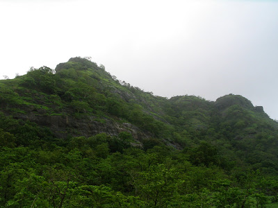
Wanting to get closer to the nature and away from city life, I went for trekking to Tandulwadi Fort. It’s a stop-over fort from Shivaji maharaj’s time and is in the middle of deep forest. Nearly 1900 feet high, the fort is surrounded by mountains and forest from all sides. A legend goes that there is a treasure somewhere along the way to top, but no one has yet found it! Also, man is yet to find the hidden caves there! And the view from the top of confluencing of rivers Vaitarna and Surya! …simply A.W.E.S.O.M.E.
Tandulwadi Fort: From the base

It takes almost 2.5 hours from the base (Tandulwadi village school), assuming you stop a lot in between and enjoy the picturesque natural beauty. Except for the final 45 minutes, the hike is not difficult. Its just walking and climbing the hill. The last 60 feet of the climb to the top is tough. We have to climb the rocks and it’s quite steep.
Final part of the hike: It's steep and rocky

I saw the confluence of rivers for the first time and what a great view it is from the top! Two rivers coming from two different directions and becoming one so suddenly is simply miraculous. Thanks to monsoon, the river is full and flowing swiftly. It is a delight!
Union of Rivers Vaitarna and Surya - A beautiful view

The cool wind makes us feel fresh despite the tough climb. There are lots of cliffs around the fort. Some have naturally created water reservoirs. There is a collection of 7 man-made water-reservoirs (called ‘hundi’ in Marathi) on the fort. It is said that they are so deep that there is a route from one ‘hundi’ to another 'hundi' from under-water.
After spending nearly 3 hours on the fort, we started descending by 4 PM. We reached the base by 5:30, a bit late due to missing the actual road. But as is said about any trek, you keep walking and you will reach the destination! How effortless it seemed to walk on concrete road after the arduous descend!
More pics here: http://picasaweb.google.com/sunil.pande/TandulwadiFortTrek?feat=email#
It was a great adventure. It feels nice to be back trekking after 4 long years of break. Can’t stop to think of another one soon J
Trek details:
| Nearest Railway station | Safale (Take Virar-Dahanu shuttle; Safale is the 2nd station – 15 minutes) |
| Base | Tandulwadi Village (10 minutes from Safale through bus/cab) |
| Height | 1900 feet |
| Time to reach the top | Approximately 2.5 hours from the base |
| Drinking water | Advisable to carry water since water on fort is not potable |
| Best time to visit | Monsoon/winter ; avoid in summer |
| Must see sights | Monsoon lake on the fort, ‘sapta-hundi’ and confluence of Rivers Vaitarna and Surya |


5 comments:
Thanks for the link to your pictures - thoroughly enjoyed not only viewing but also reading the description! Very well written blog - your keen eye to details would be quite appreciated by someone who plans to visit this place. Keep up the (trekking & being close to nature) spirit and update us all. Cheers buddy!
Hi! Its me...Milind Gavkar, all the way from Saphale where once upon a time you visited.
I just marked "Tandulwadi Fort" on www.wikimapia.org and uploaded few interesting photos of it. Please visit the place and share your invaluable views on it.
Thanks and have a nice day!
Regards,
Milind
Hey nicely written.. would like to have more information about the fort.. could u pls tell me is there single route to reach on the top ?? or so many routes to creat confusion ?? pls let me know
Nice Trek Report !keep it up!
Hey... Milind superb information. Wish I would be there for trek soon. Thank you.
Regards,
Pravin
Post a Comment